Percy Priest Lake Maps Boat Ramps
Shop Percy Priest Lake--Tennessee
 We Love Percy Priest Lake sticker
$5.98$4.98 Percy Priest Lake Bass sticker Tennessee decal
$8.98$7.98 Percy Priest Lake Crappie sticker Tennessee decal
$8.98$7.98
Percy Priest Lake Maps
On Google’s Percy Priest Lake Map use controls to scroll, zoom, topography/terrain, charts, satellite, geography etc
TWRA and Corps Of Engineers Percy Priest Lake Maps charts below
*Percy Priest Lake Maps and charts are available commercially from:
Atlantic Mapping, Inc. PO Box 7391 Marietta, GA. 30065 770-426-5768 http://www.atlanticmapping.com/
*Localwaters provides information on commercial charts availability as a public service. This is not an endorsement nor do we receive compensation from Atlantic Mapping.

Percy Priest Lake Access Sites and Boat Ramps
Map Courtesy of TWRA Region 2
Click on links below for close-up map of boat ramps and access aresas
- Anderson Boat Ramps (1)
- Bryant’s Grove boat ramp (2)
- Cook Recreation Area #1 (3)
- Cook Recreation Area #2 (4)
- East Fork boat ramp (5)
- Elm Hill Marina boat ramp (6)
- Elm Hill Park (7)
- Elm Hill Recreation Area boat ramps (8)
- Fall Creek (9)
- Fate Sanders Marina boat ramp (10)
- Fate Sanders Recreation Area (11)
- Four Corners Boat & Marina (12)
- Hamilton Creek (13)
- Hamilton Creek Boat Ramp #1 (14)
- Hamilton Creek Boat Ramp #2 (15)
- Hamilton Creek Marina (16)
- J. Percy Priest Resource Center (17)
- Jefferson Springs (18)
- Lamar Hill (19)
- Long Hunter boat ramp (20)
- Mona boat ramp (21)
- Nashville Shores (22)
- Nashville Shores Water Park (23)
- Nashville shores Yacht Club & Marina (24)
- Old Hickory (25)
- Percy Priest Marina & Yacht Club (26)
- Poole Knobs boat ramp (27)
- Poole Knobs Camp Area (28)
- Seven Points (29)
- Seven Points Recreation Area & Campground (30)
- Smith Springs Park (31)
- Smith Springs Recreation Area (32)
- Stewarts Creek (33)
- Viverette Creek (34)
- West Fork (35)
Percy Priest Lake Map User Guide Below courtesy of Nashville District Corps of Engineers
Direct Download: Percy-Priest-Lake-Map-US-COE

Map courtesy of the Nashville District of the Corps of Engineers. High res ((3300 ? 2550) link here: JPP COE
Restricted area below Percy Priest Dam NOT IMPLEMENTED due to well organized public pressure:
link to “Freedom to Fish Act” here
Map Corps of Engineer s Safety Zone, Percy Priest Lake Dam. New as of 12/14/12
Water restriction tailwater safety zone below and above Percy Priest Lake Dam

Stones River map of towns cities and highways within the watershed
Courtesy of TN Department of Environment & Conservation

Stones River map of state protected natural areas within the watershed
Courtesy of TN Department of Environment & Conservation

Percy Priest Lake map with Stones River watershed hydrology
Courtesy of TN Department of Environment & Conservation

Stones River map of ecoregions with the watershed
Courtesy of TN Department of Environment & Conservation

Stones River map of dams within the watershed
Courtesy of TN Department of Environment & Conservation
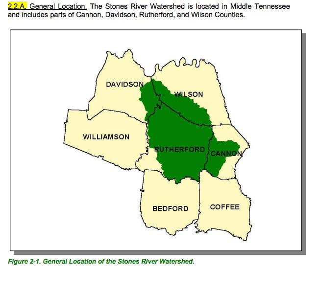
Stones River map of counties within the watershed
Courtesy of TN Department of Environment & Conservation

Percy Priest Lake map of area around Long Hunter State Park.
Link to download a high resolution PDF