Old Hickory Lake Maps Boat Ramps
Shop Old Hickory Lake--Tennessee
 Old Hickory Lake Walleye sticker Tennessee decal World Record
 Old Hickory Lake Bass sticker Tennessee decal
 We Love Old Hickory Lake sticker decal
Old Hickory Lake Maps
On Google’s Old Hickory Lake Map use controls to scroll, zoom, topography/terrain, charts, satellite, geography etc
TWRA and Corps Of Engineers Maps charts below
*Old Hickory Lake Maps and charts are available commercially from:
Atlantic Mapping, Inc. PO Box 7391 Marietta, GA. 30065 770-426-5768 http://www.atlanticmapping.com/
*Localwaters provides information on commercial charts availability as a public service. This is not an endorsement nor do we receive compensation from Atlantic Mapping.
Map of Upper Old Hickory Lake-east (Cumberland River)
Map of Lower and Middle Old Hickory Lake-west

- Western Part of Old Hickory Lake
- Map Courtesy of TWRA Region 2
-
Click on links below for close-up map of access areas and boat ramps marinas
- Anchor High Marina (1)
- Avondale Recreation Area (2)
- Blackjack Cove Marina (4)
- Cages Bend Campground (7)
- Cedar Creek Marina (10)
- Cedar Creek Park (11)
- Lock 3 (21)
- Long Branch (23)
- Mallard Point Park (24)
- Metro Beach Boat Ramp (25)
- Metro Beach Swim Area – below Dam (26)
- Metro Beach Swim Area – above Dam (27)
- Old Hickory Marina (29)
- Rockland Park (32)
- Sanders Ferry Park (34)
- Saundersville (35)
- Stark Knob (38)
- Station Camp Creek (39)
- Unnamed Boat Ramp (41)
- Walton Ferry Ramp (42)

Middle Part of Old Hickory Lake
Map Courtesy of TWRA Region 2
Click on links below for close-up map of access area and boat ramp marinas
- Barton’s Creek (3)
- Bledsoe Creek State Park boat ramp (5)
- Bull Run (6)
- Cairo (8)
- Cedar Grove (12)
- Cherokee (13)
- Ciaro Bend (14)
- Coles Ferry (15)
- Cripple Children Ramp (16)
- Davis Corner (17)
- Gallatin Steam Plant (18)
- Hunters Point boat ramp (19)
- Laquardo boat ramp (20)
- Lock 4 (22)
- Misty Cove (28)
- Old Union Hill (30)
- Second Creek (36)
- Special Needs Access (37)
- Tyree (40)
- Ziegler’s Fort (43)

Eastern Part of Old Hickory Lake
Map Courtesy of TWRA Region 2
Click on links below for close-up map of access area boat ramps marinas
- Carthage boat ramp (9)
- Ramp below Powerhouse (31)
- Rome boat ramp (33)
Old Hickory Lake Map User Guide Below courtesy of Nashville District Corps of Engineers
Direct Download: Old Hickory Lake-US-COE
Direct Link: Old Hickory Lake Map Legend

Map courtesy of the Nashville District of the Corps of Engineers. High res ((3300 ? 2550) link here: OH COE
Restricted area below Old Hickory Dam NOT IMPLEMENTED due to well organized public pressure:
link to “Freedom to Fish Act” here
Map Corps of Engineer s Safety Zone, Old Hickory Lake Dam. New as of 12/14/12
Water restriction tailwater safety zone below and above Old Hickory Lake Dam
Link to US Army Corps Of Engineers Nashville District Cumberland River Charts
Sample Corps Old Hickory Lake map chart below, this has been down-sized, large PDF’s are provided directly from the Corps of Engineers.
Printed versions available, link leads to electronic versions as well.

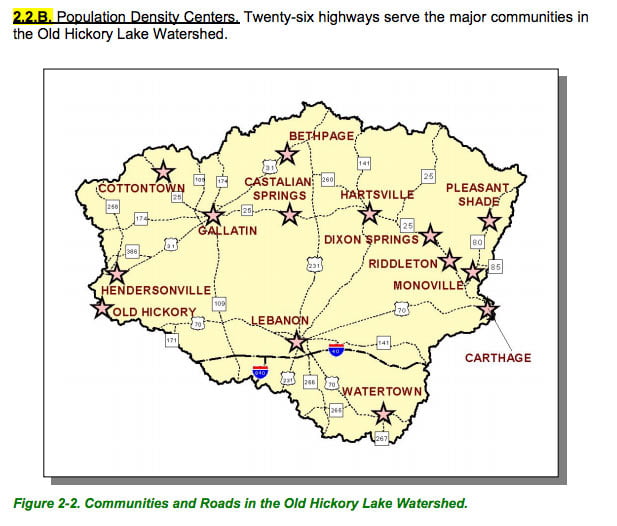
Map Courtesy of TN Department of Environment & Conservation
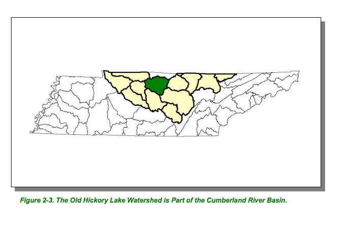
Map Courtesy of TN Department of Environment & Conservation
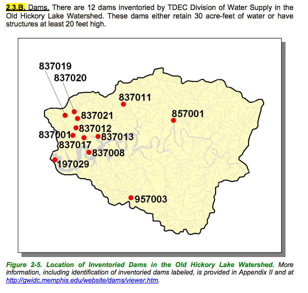
Map Courtesy of TN Department of Environment & Conservation
Map Courtesy of TN Department of Environment & Conservation
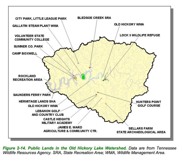
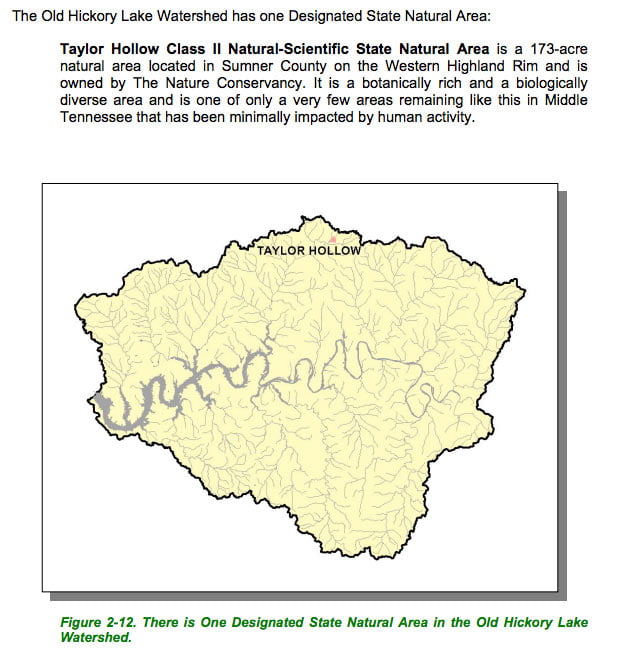
Map Courtesy of TN Department of Environment & Conservation
Map Courtesy of TN Department of Environment & Conservation
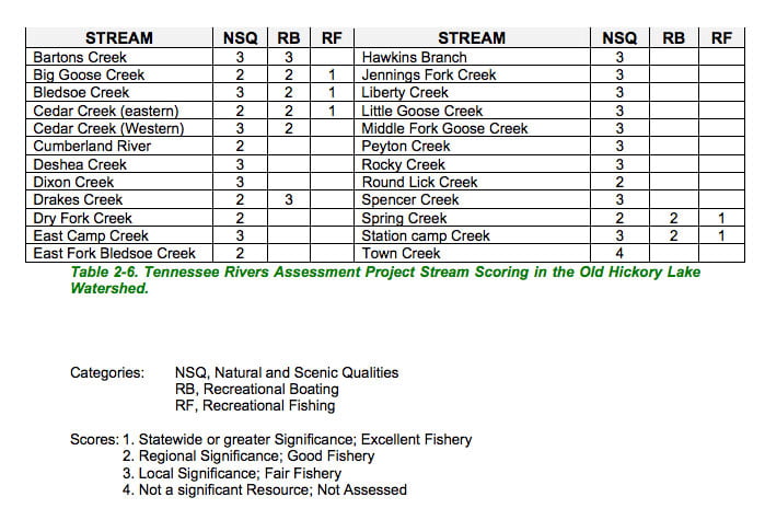
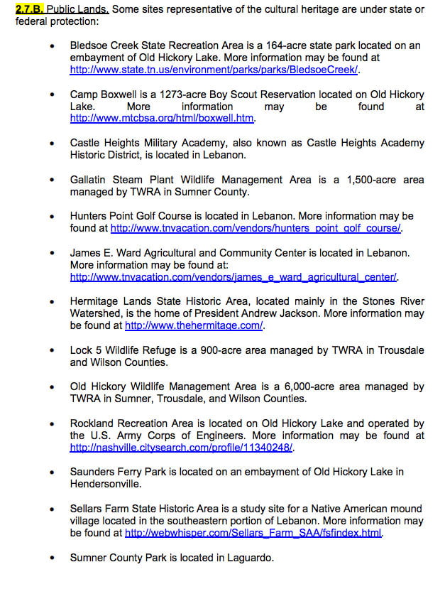
List Courtesy of TN Department of Environment & Conservation