Caney Fork River Maps
Shop Caney Fork River--Tennessee
 Caney Fork River Grandslam trout sticker Tennessee fishing Decal
$8.98$7.98 Caney Fork River Canoe sticker Tennessee Decal
$6.98$5.98 Caney Fork River Kayak sticker Tennessee Decal Paddle
$6.98$5.98 We Love Caney Fork River decal sticker
$5.98$4.98 Caney Fork River Bass sticker Smallmouth Decal Tennessee
$8.98$7.98 Caney Fork River Fly Fishing Sticker Tennessee Decal
$8.98$7.98 Caney Fork River Trout Fishing Cloth Patch Limited Edition of 100
$10.98
Caney Fork River Trout Fishing Cloth Patch Limited Edition of 100
$10.98
 Caney Fork River Brown Trout Fishing sticker Tennessee Decal
$8.98$7.98
Caney Fork River Map
On Google’s Caney Fork River Maps use controls to scroll, zoom, topography/terrain, charts, satellite, geography etc
TWRA and Corps Of Engineers Caney Fork River Maps charts below
Localwaters Caney Fork River Map of best fishing locations:
Center Hill Dam Pond – Happy Hollow – I 40 Rest Stop – Betty’s Island – Sebowisha – Kirby Road -Stonewall

Map Courtesy of TWRA Region 2
Click on links below for close-up map
- Betty’s Island Boat Ramp (1)
- Bob Lowery Sr. Boat Ramp (South Carthage) (2)
- Gordonsville (Stonewall Boat Ramp) (3)
- I-40 Welcome Center (Access area only, no boat ramp) (4)
- Other boat ramps not shown (see map below)
- Long Branch boat ramp
- Buffalo Valley boat ramp at Center Hill Dam / gravel bar
- Bettys Island boat ramp / gravel bar
- Happy Hollow boat ramp /gravel bar
- Special note: not shown on this map is the Carthage Boat Ramp. Located about 1/2 mile below the
- confluence of the Cumberland River. This is where a full Caney Fork River float ends
-
- Carthage boat ramp (9)

Caney Fork River Tennessee-tailwater-map access points courtesy US Army Corps Of Engineers
Boat Ramp not shown here has been added at Stonewall, West side of river
How to get to Betty’s Island Access on the Caney Fork by road:
Take I-40 exit#268 and go North 1.9 miles to St. Mary’s Road and turn left. Take St. Mary’s Rd 4.1 miles and you will
see a small brown Betty’s Island sign on the left at the entrance to the parking area.
From Center Hill Dam follow signs to I-40 and see above.
Caney Fork River Map: Headwaters/Source, West of Crossville TN
Caney Fork River Map: Scotts Gulf to Headwaters of Great Falls Lake
Caney Fork River Map: Great Falls Lake, confluence with Calfkiller River, Rocky River and Collins River, Rock Island
Caney Fork River Map: Rock Island, Great Falls, Headwater of Center Hill Lake, Horseshoe Bend
Caney Fork River Map: Center Hill Lake, confluence of Falling Water River, Burgess Falls,
Burgess Falls State Park, Floating Mill Park, Edgar Evans State Park, Center Hill Dam
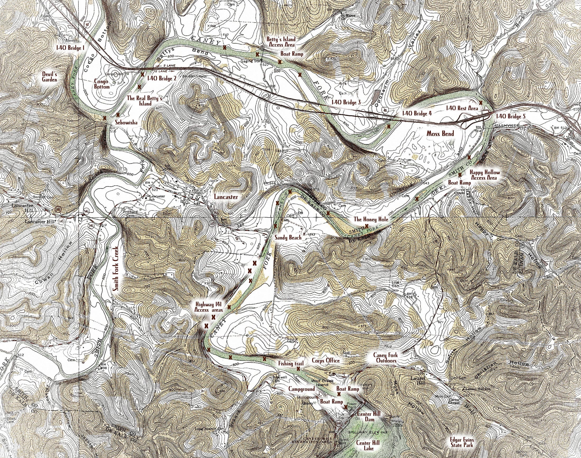
Caney Fork River Map: Center Hill Lake, Center Hill Dam, Tailwater (see top map for
access points to tailwater section), Confluence with Smith Fork Creek at Sebowisha, Confluence with Cumberland River
TWRA Access Sites Great Falls and Caney Fork River Upper

Restricted area below Center Hill Dam NOT IMPLEMENTED due to well organized public pressure:
link to “Freedom to Fish Act” here
Map courtesy of the Nashville District of the Corps of Engineers. High res ((3300 ? 2550) link here: COE CHL
Map Corps of Engineers Safety Zone, Center Hill Dam. New as of 12/14/12
Water restriction tailwater safety zone below and above Center Hill Lake Dam
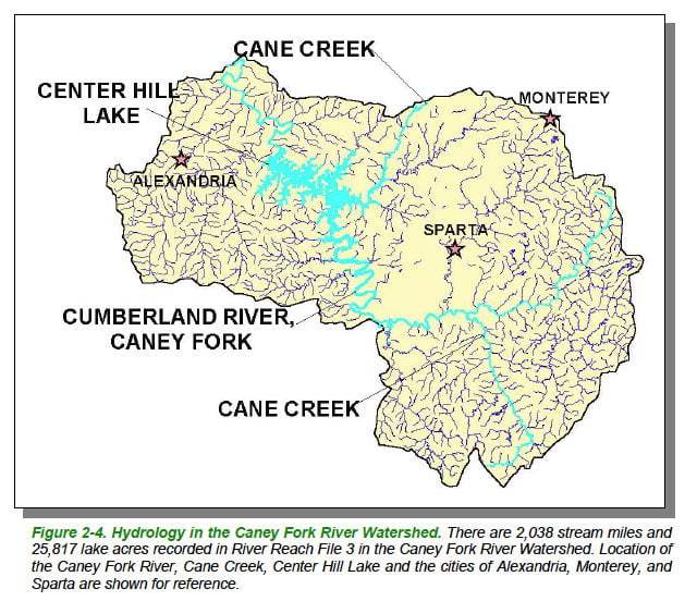
Caney Fork River Map Watershed-Courtesy of Department of Environment & Conservation
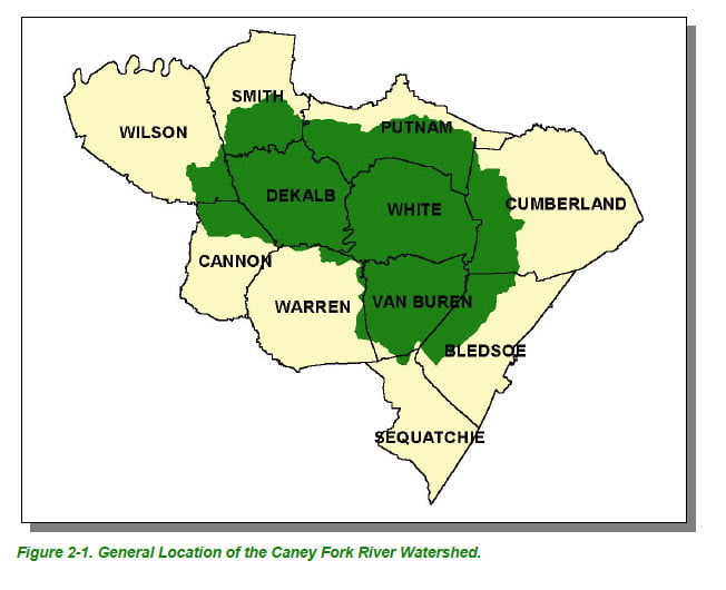
Caney Fork River Map Watershed Counties- Courtesy of Department of Environment & Conservation

Caney Fork River Map Ecoregions-Courtesy of Department of Environment & Conservation
Courtesy of Department of Environment & Conservation
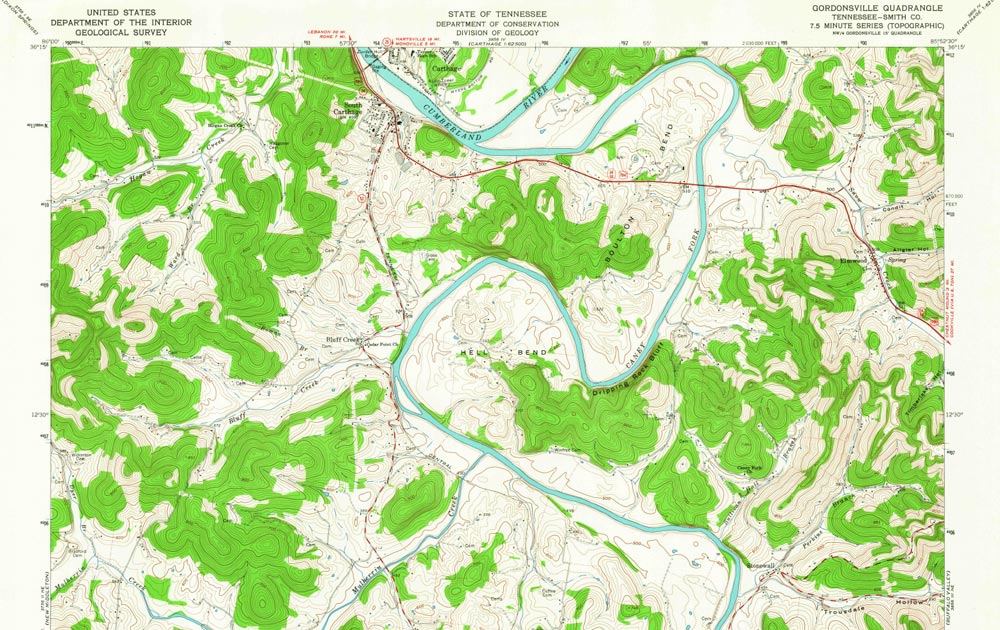 Caney Fork River Map of Hell Bend Boulton Bend near the confluence with the Cumberland River. Note that on more recent maps the place name of “Helm’s Bend” replaces that of Hell Bend marked on this map from the early 1960’s. My Boze ancestors settled on this bend in about 1803.
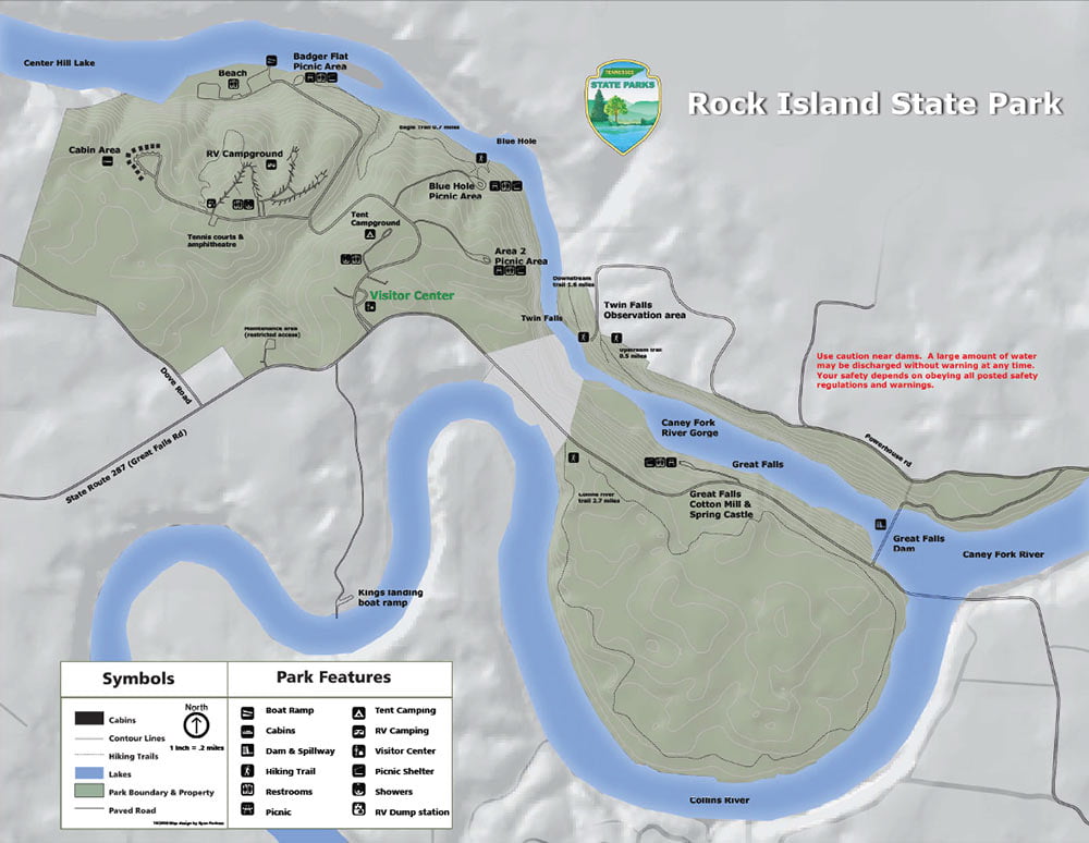
Caney Fork River map of upper Center Hill Lake, Great Falls Lake, Collins River, Rock Island State Park and the Blue Hole
Link to PDF at higher resolution for printing: Rock Island State Park