Center Hill Lake Maps
Shop Center Hill Lake--Tennessee
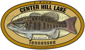 Center Hill Lake Smallmouth Bass sticker Tennessee Decal
 We Love Center Hill Lake decal sticker
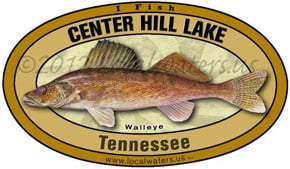 Center Hill Lake Walleye sticker Tennessee Decal fishing
Center Hill Lake Maps
On Google’s Center Hill Lake Map use controls to scroll, zoom, topography/terrain, charts, satellite, geography etc
TWRA and Corps Of Engineers Center Hill Lake Maps charts below
*Center Hill Lake maps and charts are available commercially from:
Atlantic Mapping, Inc. PO Box 7391 Marietta, GA. 30065 770-426-5768 http://www.atlanticmapping.com/
*Localwaters provides information on commercial charts availability as a public service. This is not an endorsement nor do we receive compensation from Atlantic Mapping.
Center Hill Lake Map Full Resolution Download (20 MB) PDF (Antique)
Center Hill Lake Map: Headwaters-Rock Island State Park-Horseshoe Bend-Pates Ford-
Riverine Section to Hwy 70 Bridge-Sligo-Ragland Bottom
Center Hill Lake Map: Hwy 70 Bridge-Sligo-Ragland Bottom-Puckett Point-
Big Island-Falling Water River Cove-Hurricane Bridge-Hwy 56 Bridge
Hurricane Bridge-Hwy 56 Bridge-Floating Mill Campground-Holmes Creek Cove-
Indian Creek Cove-Cove Hollow-Edgar Evins State Park-Center Hill Dam

Map Courtesy of TWRA Region 2
Click on links below for close up maps of boat ramps
- Austin Bottoms (1)
- Big Hurricane Creek Boat Ramp (2)
- Cane Hollow Boat Ramp (3)
- Center Hill Marina Boat Ramp (4)
- Cookeville Dock Boat Ramp (5)
- Ditty Bottom Boat Ramp (6)
- Dubland Boat Ramp (7)
- Edgar Evans Marina Boat Ramp (8)
- Edgar Evans State Park #1 Boat Ramps (9)
- Edgar Evans State Park #2 Boat Ramps (10)
- Floating Mill Recreation Area Boat Ramp (11)
- Hickory Ramp Boat Ramp (12)
- Hidden Harbor Marina Boat Ramp (13)
- Holmes Creek Recreation Area Boat Ramp (14)
- Horseshoe Bend Marina Boat Ramp (15)
- Hurricane Bridge Boat Ramp (16)
- Hurricane Marina Boat Ramp (17)
- Johnson Chapel Boat Ramp (18)
- Lakeside Resort Boat Ramp (19)
- Old Johnson Chapel Boat Ramp (20)
- Pates Ford Marina Boat Ramp (21)
- Pin Hook Boat Ramp (22)
- Pine Creek (23)
- Potts Camp (24)
- Puckett’s Point Boat Ramp (25)
- Ragland Bottom Boat Ramp (26)
- Rock Island State Park Boat Ramp USE CAUTION AT LOW WATER (27)
- Sligo Marina Boat Ramp (28)
- Three Islands Boat Ramp (29)
- Tulip Popular Bay (30)
- Warren County Boat Ramp (31)
Center Hill Lake Map Below user guide courtesy of Nashville District Corps of Engineers
Direct Download: Center Hill Lake Map-US-COE

Map courtesy of the Nashville District of the Corps of Engineers. High res ((3300 ? 2550) link here: COE CHL
Restricted area below Center Hill Dam NOT IMPLEMENTED due to well organized public pressure:
link to “Freedom to Fish Act” here
Map Corps of Engineers Safety Zone, Center Hill Dam. New as of 12/14/12
Proposed water restriction tailwater safety zone below and above Center Hill Lake Dam
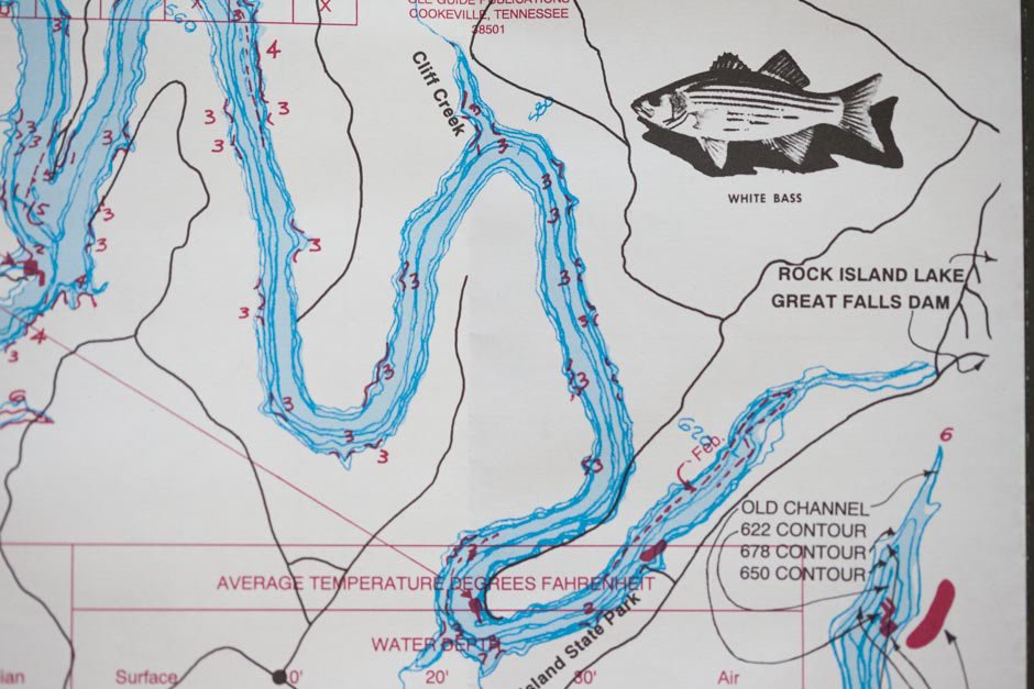 Center Hill Lake Map Place Names: Blue Hole, Cliff Creek, Rock Island
 Center Hill Lake Map Place Names: Cliff Creek, Cedar Creek, Sink Creek, Stillhouse Branch, Townsend Creek, Ferguson Creek, Pine Creek,[
 Center Hill Lake Map Place Names: Britch Creek, Fall Creek, Townsend Creek, Ferguson Creek, Pine Creek, Peeled Chestnut, Webb’s Camp, Four Seasons Marina.
 Center Hill Lake Map Place Names: Britch Creek, Fall Creek, Long Branch, Ferguson Creek, Ragland Bottom, Pucketts Point, Peeled Chestnut, Webb’s Camp,
Four Seasons Marina, Eagle Creek, Sligo (location shown for Sligo is incorrect-see Hwy 70 crossing)
Center Hill Lake Map Place Names: Britch Creek, Fall Creek, Long Branch, Ferguson Creek, Ragland Bottom, Pucketts Point, Peeled Chestnut,
Webb’s Camp, Four Seasons Marina, Eagle Creek, Sligo (location shown for Sligo is incorrect-see Hwy 70 crossing)
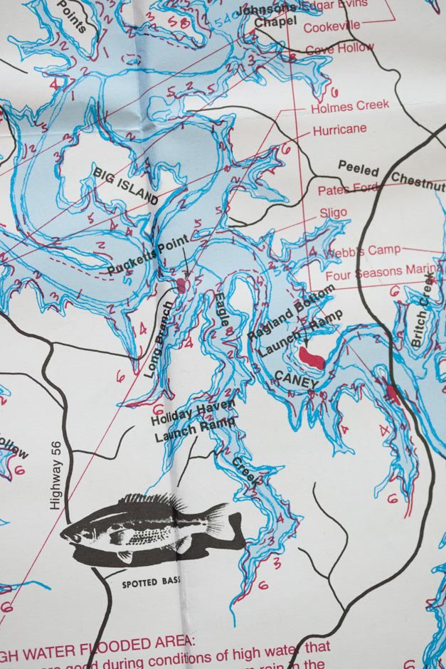 Center Hill Lake Map Place Names: Britch Creek, Long Branch, Ragland Bottom, Pucketts Point, Peeled Chestnut, Webb’s Camp, Four Seasons Marina, Big Island, Eagle Creek,
Sligo (location shown for Sligo is incorrect-see Hwy 70 crossing) Holiday Haven, Johnsons Chapel
 Center Hill Lake Map Place Names: Burgess Falls, Cane Creek, Falling Water River, Taylor Falls, Taylor Falls Creek, Jones Creek, Johnsons Chapel, Dry Creek
 Center Hill Lake Map Place Names: Falling Water River, Dry Creek, Johnsons Chapel, Five Points, Long Branch,
Eagle Creek, Big Island, Pucketts Point, Ragland Bottom, Caney Fork River
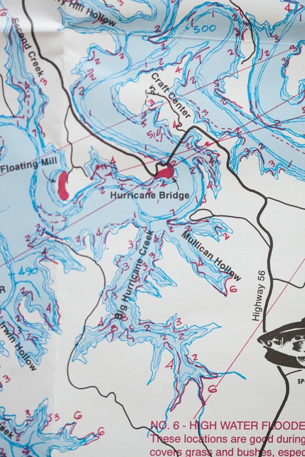 Center Hill Lake Map Place Names: Craft Center (Appalachian Center for Arts and Crafts) Caney Fork River, Floating Mill, Hurricane Bridge,
Mullican Hollow, Big Hurricane Creek, Irwin Hollow, Cherry Hill Hollow, Second Creek,
 Center Hill Lake Map Place Names: Craft Center (Appalachian Center for Arts and Crafts) Caney Fork River, Irwin Hollow, Cherry Hill Hollow, Second Creek, Mine Lick Creek, Cherry Hill
 Center Hill Lake Map Place Names: Craft Center (Appalachian Center for Arts and Crafts) Caney Fork River, Irwin Hollow, Cherry Hill Hollow, Second Creek, Mine Lick Creek, Cherry Hill ,
Florida Branch, Holmes Creek, Raccoon Hollow, Big Hurricane Creek, Floating Mill, Little Hurricane Creek, Cherry Hill Hollow,
 Center Hill Lake Map Place Names: Caney Fork River,Jones Fork, Cherry Hill, Indian Creek, Second Creek, Cherry Hill ,Holmes Creek, Raccoon Hollow, Big Hurricane Creek, Floating Mill
 Center Hill Lake Map Place Names: Caney Fork River, Jones Fork, Indian Creek, Cherry Hill ,Holmes Creek, Raccoon Hollow, Edgar Evins,
 Center Hill Lake Map Place Names: Caney Fork River, Jones Fork, Wolf Creek, Merrite Hollow, Hale Branch, Cove Hollow, Indian Creek, Second Creek, Cherry Hill, Center Hill Dam


Center Hill Lake Fishing Guide Map for Center Hill Lake. Out of Print Ole Guide Company that published it is out of business.
Attemptes to contact them were unsuccessful. No date appears on map but looks to be circa 1950. A high resolution version is made available for download,
no copyright, public domain. Advice on fishing Center Hill Lake appears on back of map and is credited to Bill Maffett.
A friend gave me his only copy and I’ve never seen another
View Full Resolution Map of Center Hill Lake Fishing Guide (Out of print)
Center Hill Lake Map Full Resolution Download (20 MB) PDF (Antique)

Center Hill Lake Maps Indian Creek Arm
Maps below are of the Caney Fork River Watershed that includes Center Hill Lake
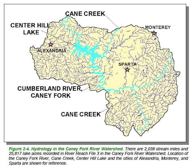
Caney Fork River Map Watershed -Courtesy of Department of Environment & Conservation
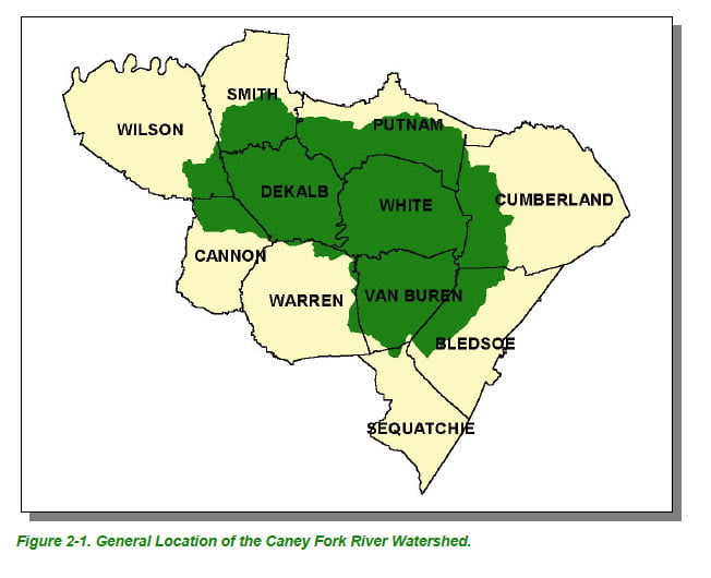
Caney Fork River Map Watershed Counties- Courtesy of Department of Environment & Conservation

Caney Fork River Map Ecoregions-Courtesy of Department of Environment & Conservation
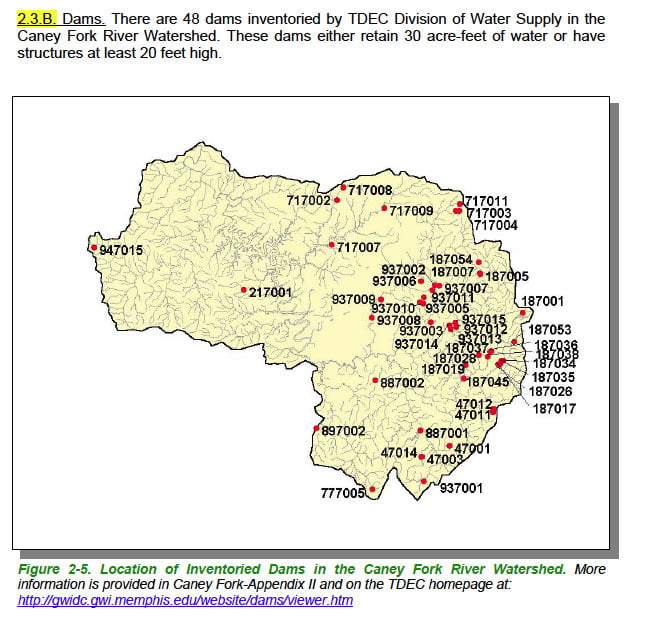
Center Hill Lake Maps Courtesy of Tennessee Department of Environment & Conservation
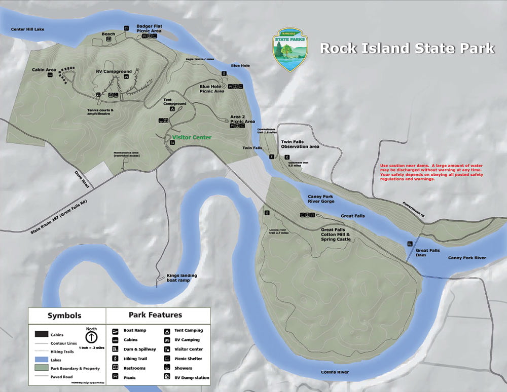
Center Hill Lake map of upper Caney Fork River , Great Falls Lake, Collins River, Rock Island State Park and the Blue Hole
Link to PDF at higher resolution for printing: Rock Island State Park